After clearing customs, our buses took us to the Soo Locks Visitor Center, located in the park adjacent to the locks. It also happened to be adjacent to downtown and a variety of touristy shops. All of our explorations were on the Michigan side of the locks. Were I to return, I'd make it a point to visit the Sault Ste. Marie Canal National Historic Site on the Canadian side where visitors can get up close and personal. Some of our group had planned to take a kayaking expedition through the Canadian locks, but it was cancelled on account of wind. Very disappointing.
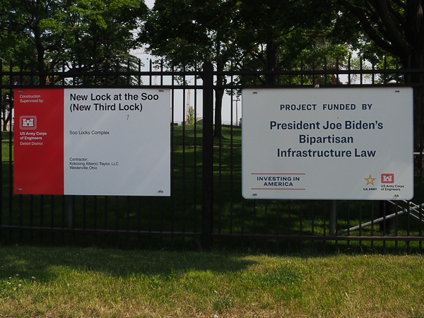
This display at the entrance to the park was not exactly "bipartisan."
We didn't find a lot of visible support for President Trump and his policies in our travels. Neither of us recalls seeing a single Trump sign, a common sight at our home in Virginia.
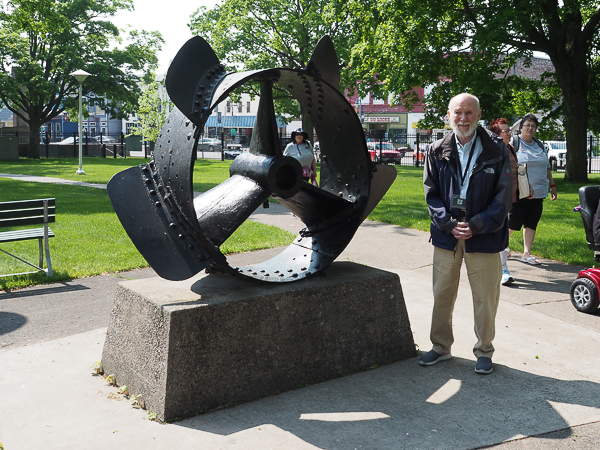
We were puzzled by this large display in the park. The only identification was a plaque stating: "Propeller from the Independence, First Steamer on Lake Superior, 1845-1853."
I've been able to find information about the Independence, but not about the unusual propeller. I guess it didn't catch on.
The Independence was brought to Lake Superior by dragging over the portage around the Sault rapids. The rapids still exist in the area between the US and Canadian locks.
The "mother ship" of the Great Lakes Shipwreck Museum is located at Whitefish Point, at the beginning of the Lake Superior "shipwreck coast" that runs from the point to Munising, where we visited the Painted Rocks.
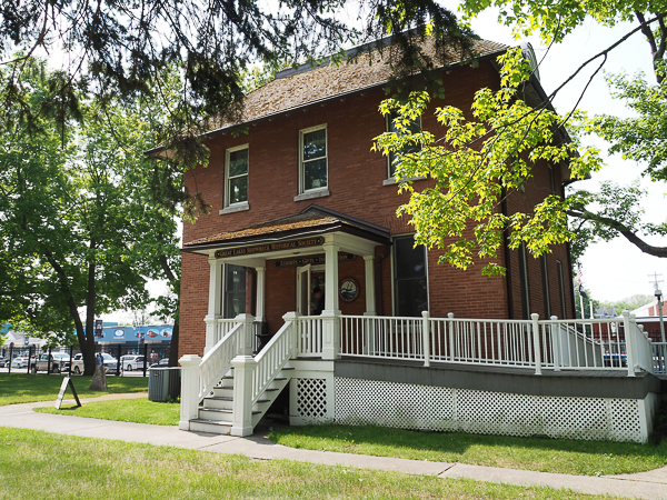
This historic Weather Bureau building houses an "outpost" site of the museum that is open in summer months. The building was built in 1899 to house a forecaster and his family. The forecaster was responsible for collecting and distributing weather reports and advisories to the ships passing the canal. The Weather Service abandoned the building in 1939 as electronic communication rendered communication with ships less personal but more efficient.
It was used by the Merchant Marine Library Association from 1948-2004. The Shipwreck Society then signed a lease with the Corps of Engineers, which owns the building, and restored it.
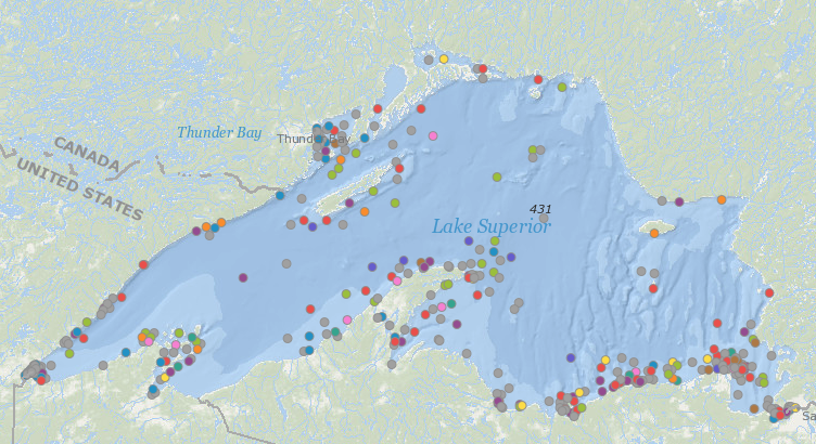
I have cribbed this map from the site: https://www.nplsf.org/post/lake-superior-shipwrecks. I would have simply referenced the page, but the interesting map is buried under a discussion about individual notable wrecks. The map was produced by Nathan Koski the maps creator, and Dave Swayze, creator of the data. I hope this is adequate acknowledgment.
The "shipwreck coast" in the lower right of the image is clearly indicated. When the wind is coming from the NW as it often does in large storms, it has a long reach to create punishing waves that then push hapless ships onto the rocky SE shore. Relatively few wrecks occur in open water where ships have room to manouver.
The most authoritative-looking site for information on Lake Superior wave formation (UCAR) is missing the subject page. (Anti-science conspiracy? Surely not.) There is a good article elsewhere on rogue waves that at least explains how waves can interact on this lake to devastating effect. The Apostle Islands referenced in the article are near the peninsula by Duluth, another well-decorated area on this map.
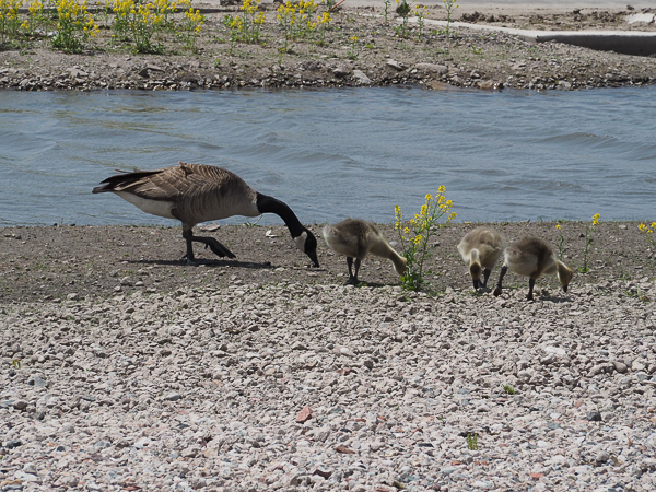
This far-from-endangered Canada goose family was hanging out on the pier near our ship. Papa goose was nearby keeping watch. The adjacent water was quite shallow and a great place to introduce goslings to swimming.
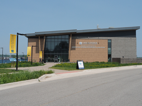
The informative Lake Superior State University Center for Freshwater Research and Education, was an easy walk from our ship. It was open especially for us on this Sunday and is well worth a visit.
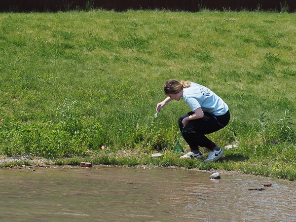
One of the student volunteers is searching for samples to show off their microscope. She was disappointed at finding only a few tiny critters for us to ogle.
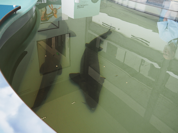
The Center is home to a couple of 5-year-old (estimated) Great Lakes Sturgeon. The fish had been rescued from another program that would otherwise have destroyed them and are now seemingly content in a purpose-built pond within the center.
Since the fish have been in captivity, they are ineligible to be returned to the lakes. I hope the center has a long-range plan for them as they can live up to 150 years.
The fish are still too young for the researchers to determine if they are male or female. It may be another 10 to 15 years before they reach sexual maturity. Many people took the opportunity to "pet" the fish, but that seemed rude to me. I confess that the fish didn't appear to notice, much less be offended.
Sturgeon are now protected, at least in Michigan. Their numbers are estimated to be about 1 percent of their historical abundance.
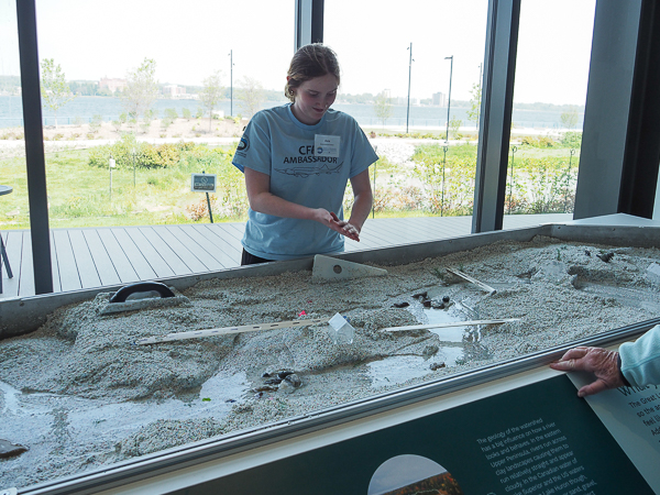
Our favorite exhibit was this stream table. The link points to a specific manufacturer of such tables, but the description is very similar to what we saw.
Jim and I spent quite a bit of time here chatting with the student as she manipulated the sand and observing the resultant erosion and constant rechanneling.
The US Army Corps of Engineers in my hometown of Vicksburg, MS, created much larger physical models to study the Mississippi River system. There was a huge one covering 200 acres in Clinton, MS, and a smaller indoor one at the Corps facility in Vicksburg. The smaller one was eliminated when I was in high school or college. The larger one still exists, but is much deteriorated.
Computer modeling is more accurate and efficient, but tables like this are still fascinating. Nothing works like getting your hands wet. And it's much more hygienic than the makeshift models I made in gutters and drainage ditches as a child.
Not much stands up to flowing water.
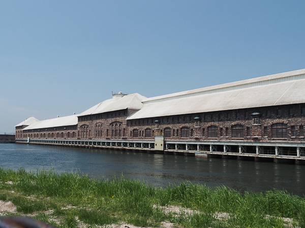
Adjacent to the LSSU site is the Cloverland Electric Cooperative Hydro Electric Plant. The huge (1/4 mile wide) plant opened in 1902. It was constructed from sandstone removed from the canal that supplies it with Lake Superior water. The flow through the canal is controlled by headgates at its entry.
At one time annual tours were offered, but these are no longer available.
Original turbines are still in use. Their manufacturers are no longer in existence so replacement parts are made in-house. (I couldn't find if they were using 3D printing yet.
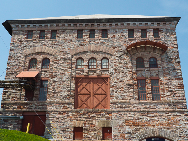
The eastern-most end of the plant is used by LSSU as a fish hatchery. The volunteers told us that they hope to someday offer tours, but these are not yet available.
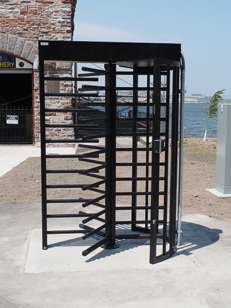
Jim and I were both puzzled by this sturdy set-in-concrete turnstyle outside the entrance to the fish hatchery. No one could tell us about it. There was no indication that there was ever a fence connected to it. Maybe they are planning for future tours???
That evening we pulled away from the dock and joined the procession of ships and boats down the St. Marys River.
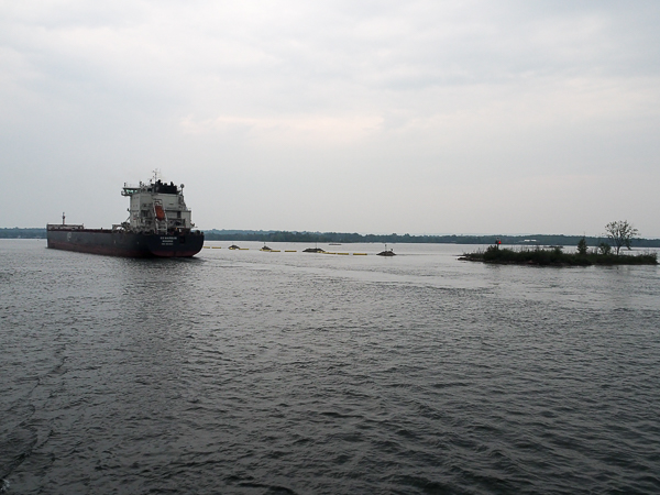
The G3 Marquis started life in a Chinese shipyard and traveled across the Pacific to arrive at Montreal in 2015. She and her sister ships provide a 45 percent improved energy efficiency have have specialized equipment that removes 97 percent of sulfur oxide emissions. She is 728' long.
The river downstream of the locks is twisty and filled with islands large and small.
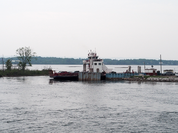
Sugar Island is inhabited by not quite 700 people and reachable only by ferry.
Another island we passed is Neebish Island. The channel divides there with upbound traffic passing the island on its eastern side and downbound traffic on its western side. Its permanent population is 90. It is only accessible by water and there is no ferry service between 1 January and 15 April. Isolated!
An overview of the river from Sault Ste. Marie to Lake Huron may be seen at the link (scroll down a bit).
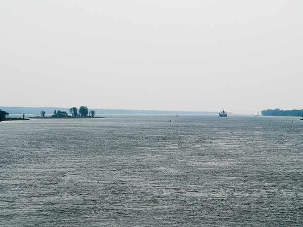
The C3 Marquis is outrunning us as we proceed down the river.
At this point it got too dark to take pictures, but I still enjoyed the passing scenery.
Click your "back" button to return to the previous page or click for our picture album.